
(ASB) Asbury
Location:
Patuxent River, Calvert County, Maryland
Site Parameters
- Coast Type: Embayed
- Body of Water: Patuxent River
- Shore Direction of Face: Northwest
- Beach Type: High Bank
- Average Shore Height: 40 feet
- Average Fetch: 3 nautical mile
- Distance to 6ft Contour:
- Avg Pre-constructuion Beach Width: 25 feet
Land Use: Residential
Ownership: Private
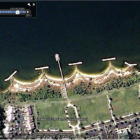
Problem: Severe erosion of the 40 ft upland bank would jeopardize the planned construction of an upscale retirement community.
Purpose: Shore protection, recreation
Prior to the construction of an upscale retirement community, the issue of the severely eroding banks had to be addressed. These 40 ft high sand rich banks had a historic erosion rate of 2 ft/yr. The project is situated within a larger shoreline reach extending from Hooper's Neck, north of the site, to Point Patience approximately one mile downstream. The morphologic expression of this larger reach and the historic pattern of shoreline change indicate that the reach is dominated by wave action from the northwest, which has a 7 mile fetch, causing alongshore sediment transport in the downstream direction. Asbury management desired a recreational, but protective beach and opted for a headland breakwater system utilizing the sand resource in the banks. This readily available sand represented a significant cost savings relative to the upland sources. The Asbury project is about 1,900 ft long and consists of several elements including three straight headland breakwaters, 110 ft long with gaps 200 ft and two transitional breakwaters 130 ft and 90 ft long on the downriver (downdrift) and upriver (updrift) ends, respectively. The project is bounded by a revetment and a short spur on both the downriver and upriver ends of the project. In addition, about 30,000 cy of sand was mined from the adjacent banks, and wetland vegetation was planted behind each breakwater and along the backshore. Beach berms were built at +3 ft and +6 ft MLW to address runup from the seasonal wind/wave climate and the 50 yr event. Additional project parameters accounted for in the design process included: the close proximity of proposed development to the shoreline; the sand rich 40 ft eroding bluffs; upland drainage had to pass through shoreline outfalls; and potential downdrift impacts.