
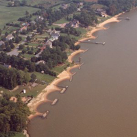
(DMF) Drummonds Field
Location:
James River, James River County, Virginia
Site Parameters
- Average Shore Height: 2 feet
- Distance to 6ft Contour: 1800 feet
- Date Installed: September 1985
- Type: Headland Breakwaters
- Number of Breakwaters: 6
- Number of Bays: 5
- Shore Type: High Bank
- Coast Type: Embayed
- Body of Water : James River
- Shore Direction of Face: South West
Land Use: Residential
Ownership: Privately owned
Problem: Moderate erosion of high upland bank with severe groundwater problems
Project purpose: Shore protection and enhance community recreational beach area
The developer took the chance on a breakwater system when only one system had been installed in Chesapeake Bay estuarine system. This early project, installed 1985, is 1,300 ft in length. The first phase consisted of a series of seven headland breakwaters and beach fill; the second phase was added to the upriver property two years later and consisted of 3 headland breakwaters and beach fill. The primary design method utilized the shore morphology between two existing cypress tree headlands and pocket beach that had been stable for 20 years. A breakwater unit was placed off each headland, and the natural pocket beach dimensions were used to template the remaining system.
View this location on the Breakwaters Map