
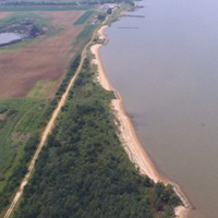
(HIH) Hog Island Headlands
Location:
James River, Surry County, Virginia
Site Parameters
- Coast Type: Embayed
- Body of Water: James River
- Shore Direction of Face: North East
- Shore Type: Low Bank
- Average Shore Height: 8 feet
- Average Fetch: 2 nautical mile
- Distance to 6ft Contour: 18,228 ft.
- Land Use: State Agriculture
- Date Installed: October 1987
- Type: Headland Control
- Number of Breakwaters: 3
- Number of Bays: 2
Installed in 1986, the project protected 2,000 ft of shore with 3 headland breakwaters spaced relatively far apart and close to shore in order to establish firmly attached headland features. The adjacent shore has been allowed to erode toward equilibrium. The system was designed using a combination of shore morphology evolution and Static Equilibrium Bay model to predict long term planform configuration. Beach fill and wetland plants were placed on constructed tombolos.