
(LUT) Luter
Location:
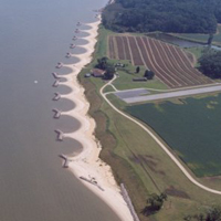
James River, Isle of Wight County, Virginia
Site Parameters
- Coast Type: Straight
- Body of Water: James River
- Shore Direction of Face: North North East
- Shore Type: High Bank
- Average Shore Height: 30 feet
- Average Fetch: 7 nautical mile
- Distance to 6ft Contour: 1066 feet
- Type: Headland Breakwaters
- Number of Breakwaters: 13
- Number of Bays: 12
Land Use: Agriculture
Ownership: Private
Problem: Severe erosion of 30 ft upland banks
Purpose: Shore protection and habitat enhancement
Single property owner desired system like the Van Dyke project. The system was designed using shore evolution and a Mb:Gb relationship of 1:1.65. Archaeological resources also were a factor in project design as well as upland drainage and interfacing with downdrift shore. The 3,000 ft system was installed 1998. Thirteen headland breakwaters as well as a revetment and spur on upriver boundary and a low, interfacing breakwater on downriver boundary were constructed. Beach fill was obtained from upland borrow pit. Wetlands plantings and bank grading also occurred. Two archaeological sites had to be protected using bank fill instead of grading which pushed the system out at those points.